|
|
|||||||||||||||||
| Point ID: 7484 | Downloads | Plots | Site Data | Code: 70429 |
|
|
|||||||||||||||||
| Download | |
|---|---|
| Site Descriptor Information | Site Time Series Data |
| Link to all available data | |
| View: | Time Series | All |
| Units: | m3/s |
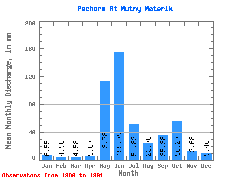
| Statistic | Jan | Feb | Mar | Apr | May | Jun | Jul | Aug | Sep | Oct | Nov | Dec | Annual |
|---|---|---|---|---|---|---|---|---|---|---|---|---|---|
| Mean | 6.55 | 5.02 | 4.58 | 5.87 | 113.76 | 155.79 | 51.81 | 23.77 | 35.38 | 56.26 | 12.68 | 9.46 | 484.36 |
| Standard Deviation | 1.28 | 1.22 | 0.99 | 3.44 | 53.53 | 52.24 | 16.47 | 7.89 | 15.12 | 86.60 | 4.08 | 2.02 | 89.84 |
| Min | 5.28 | 3.55 | 3.17 | 3.17 | 34.62 | 83.45 | 30.57 | 13.72 | 13.28 | 14.37 | 8.23 | 7.18 | 403.39 |
| Max | 9.18 | 6.99 | 6.13 | 15.68 | 219.47 | 254.14 | 82.04 | 39.71 | 55.51 | 299.15 | 22.63 | 13.32 | 667.25 |
| Coefficient of Variation | 0.20 | 0.24 | 0.22 | 0.59 | 0.47 | 0.34 | 0.32 | 0.33 | 0.43 | 1.54 | 0.32 | 0.21 | 0.18 |
 Return to R-Arctic Net Home Page