|
|
|||||||||||||||||
| Point ID: 748 | Downloads | Plots | Site Data | Code: 07GD002 |
|
|
|||||||||||||||||
| Download | |
|---|---|
| Site Descriptor Information | Site Time Series Data |
| Link to all available data | |
| View: | Time Series | All |
| Units: | mm |
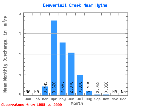
| Statistic | Jan | Feb | Mar | Apr | May | Jun | Jul | Aug | Sep | Oct | Nov | Dec | Annual |
|---|---|---|---|---|---|---|---|---|---|---|---|---|---|
| Mean | 0.44 | 3.62 | 2.56 | 2.07 | 0.99 | 0.21 | 0.05 | 0.05 | |||||
| Standard Deviation | 0.56 | 5.16 | 3.77 | 4.80 | 1.99 | 0.35 | 0.10 | 0.14 | |||||
| Min | 0.00 | 0.13 | 0.01 | 0.01 | 0.00 | 0.00 | 0.00 | 0.00 | |||||
| Max | 1.96 | 19.20 | 15.30 | 20.40 | 7.36 | 1.11 | 0.39 | 0.56 | |||||
| Coefficient of Variation | 1.26 | 1.43 | 1.47 | 2.32 | 2.01 | 1.64 | 1.98 | 2.73 |
 Return to R-Arctic Net Home Page