|
|
|||||||||||||||||
| Point ID: 748 | Downloads | Plots | Site Data | Code: 07GD002 |
|
|
|||||||||||||||||
| Download | |
|---|---|
| Site Descriptor Information | Site Time Series Data |
| Link to all available data | |
| View: | Time Series | All |
| Units: | m3/s |
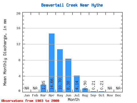
| Statistic | Jan | Feb | Mar | Apr | May | Jun | Jul | Aug | Sep | Oct | Nov | Dec | Annual |
|---|---|---|---|---|---|---|---|---|---|---|---|---|---|
| Mean | 1.79 | 14.18 | 10.34 | 8.10 | 4.00 | 0.87 | 0.21 | 0.20 | |||||
| Standard Deviation | 2.25 | 20.21 | 15.24 | 18.81 | 8.04 | 1.42 | 0.41 | 0.55 | |||||
| Min | 0.00 | 0.53 | 0.02 | 0.02 | 0.00 | 0.00 | 0.00 | 0.00 | |||||
| Max | 7.93 | 75.18 | 61.89 | 79.87 | 29.77 | 4.49 | 1.53 | 2.27 | |||||
| Coefficient of Variation | 1.26 | 1.43 | 1.47 | 2.32 | 2.01 | 1.64 | 1.98 | 2.73 |
 Return to R-Arctic Net Home Page