|
|
|||||||||||||||||
| Point ID: 7478 | Downloads | Plots | Site Data | Code: 70402 |
|
|
|||||||||||||||||
| Download | |
|---|---|
| Site Descriptor Information | Site Time Series Data |
| Link to all available data | |
| View: | Time Series | All |
| Units: | mm |
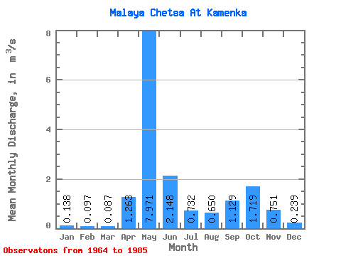
| Statistic | Jan | Feb | Mar | Apr | May | Jun | Jul | Aug | Sep | Oct | Nov | Dec | Annual |
|---|---|---|---|---|---|---|---|---|---|---|---|---|---|
| Mean | 0.14 | 0.10 | 0.09 | 1.26 | 7.97 | 2.15 | 0.73 | 0.65 | 1.13 | 1.72 | 0.75 | 0.24 | 1.42 |
| Standard Deviation | 0.06 | 0.05 | 0.04 | 3.08 | 2.66 | 1.60 | 0.50 | 0.45 | 0.66 | 1.18 | 0.60 | 0.14 | 0.33 |
| Min | 0.03 | 0.01 | 0.03 | 0.04 | 2.87 | 0.58 | 0.17 | 0.16 | 0.21 | 0.37 | 0.02 | 0.05 | 0.90 |
| Max | 0.31 | 0.24 | 0.14 | 13.10 | 11.70 | 6.78 | 2.06 | 1.56 | 2.85 | 5.30 | 2.30 | 0.64 | 2.06 |
| Coefficient of Variation | 0.45 | 0.49 | 0.41 | 2.44 | 0.33 | 0.75 | 0.69 | 0.68 | 0.59 | 0.69 | 0.80 | 0.58 | 0.23 |
 Return to R-Arctic Net Home Page