|
|
|||||||||||||||||
| Point ID: 7478 | Downloads | Plots | Site Data | Code: 70402 |
|
|
|||||||||||||||||
| Download | |
|---|---|
| Site Descriptor Information | Site Time Series Data |
| Link to all available data | |
| View: | Time Series | All |
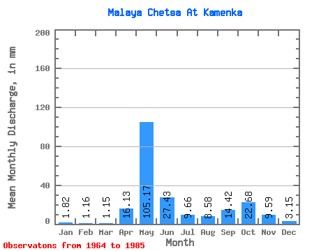
| Units: | m3/s |
| Statistic | Jan | Feb | Mar | Apr | May | Jun | Jul | Aug | Sep | Oct | Nov | Dec | Annual |
|---|---|---|---|---|---|---|---|---|---|---|---|---|---|
| Mean | 1.82 | 1.17 | 1.15 | 16.13 | 105.16 | 27.42 | 9.66 | 8.57 | 14.42 | 22.68 | 9.59 | 3.16 | 221.41 |
| Standard Deviation | 0.81 | 0.58 | 0.47 | 39.27 | 35.04 | 20.47 | 6.63 | 5.87 | 8.45 | 15.59 | 7.70 | 1.84 | 51.54 |
| Min | 0.42 | 0.13 | 0.40 | 0.45 | 37.86 | 7.41 | 2.24 | 2.11 | 2.68 | 4.88 | 0.27 | 0.70 | 140.12 |
| Max | 4.09 | 2.88 | 1.85 | 167.27 | 154.35 | 86.57 | 27.18 | 20.58 | 36.39 | 69.92 | 29.37 | 8.44 | 320.26 |
| Coefficient of Variation | 0.45 | 0.49 | 0.41 | 2.44 | 0.33 | 0.75 | 0.69 | 0.68 | 0.59 | 0.69 | 0.80 | 0.58 | 0.23 |
 Return to R-Arctic Net Home Page