|
|
|||||||||||||||||
| Point ID: 7476 | Downloads | Plots | Site Data | Code: 70399 |
|
|
|||||||||||||||||
| Download | |
|---|---|
| Site Descriptor Information | Site Time Series Data |
| Link to all available data | |
| View: | Time Series | All |
| Units: | mm |
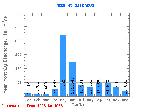
| Statistic | Jan | Feb | Mar | Apr | May | Jun | Jul | Aug | Sep | Oct | Nov | Dec | Annual |
|---|---|---|---|---|---|---|---|---|---|---|---|---|---|
| Mean | 12.12 | 9.70 | 8.48 | 26.70 | 221.60 | 121.64 | 42.59 | 32.36 | 48.46 | 51.57 | 35.43 | 18.01 | 52.20 |
| Standard Deviation | 3.33 | 2.37 | 1.98 | 40.03 | 69.70 | 85.24 | 21.10 | 19.79 | 22.91 | 24.09 | 18.00 | 5.99 | 9.30 |
| Min | 7.15 | 5.38 | 4.50 | 5.73 | 42.70 | 32.70 | 19.90 | 10.50 | 10.30 | 18.70 | 14.40 | 8.39 | 30.00 |
| Max | 19.40 | 15.00 | 13.20 | 160.00 | 330.00 | 394.00 | 113.00 | 105.00 | 98.00 | 105.00 | 99.30 | 33.50 | 69.44 |
| Coefficient of Variation | 0.27 | 0.24 | 0.23 | 1.50 | 0.32 | 0.70 | 0.49 | 0.61 | 0.47 | 0.47 | 0.51 | 0.33 | 0.18 |
 Return to R-Arctic Net Home Page