|
|
|||||||||||||||||
| Point ID: 7476 | Downloads | Plots | Site Data | Code: 70399 |
|
|
|||||||||||||||||
| Download | |
|---|---|
| Site Descriptor Information | Site Time Series Data |
| Link to all available data | |
| View: | Time Series | All |
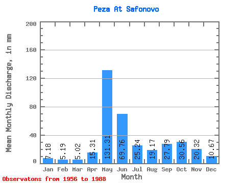
| Units: | m3/s |
| Statistic | Jan | Feb | Mar | Apr | May | Jun | Jul | Aug | Sep | Oct | Nov | Dec | Annual |
|---|---|---|---|---|---|---|---|---|---|---|---|---|---|
| Mean | 7.18 | 5.24 | 5.02 | 15.31 | 131.29 | 69.76 | 25.24 | 19.17 | 27.79 | 30.55 | 20.32 | 10.67 | 364.49 |
| Standard Deviation | 1.97 | 1.28 | 1.17 | 22.95 | 41.30 | 48.88 | 12.50 | 11.72 | 13.13 | 14.28 | 10.32 | 3.55 | 64.92 |
| Min | 4.24 | 2.90 | 2.67 | 3.29 | 25.30 | 18.75 | 11.79 | 6.22 | 5.91 | 11.08 | 8.26 | 4.97 | 209.49 |
| Max | 11.49 | 8.10 | 7.82 | 91.75 | 195.52 | 225.94 | 66.95 | 62.21 | 56.20 | 62.21 | 56.94 | 19.85 | 484.88 |
| Coefficient of Variation | 0.27 | 0.24 | 0.23 | 1.50 | 0.32 | 0.70 | 0.49 | 0.61 | 0.47 | 0.47 | 0.51 | 0.33 | 0.18 |
 Return to R-Arctic Net Home Page