|
|
|||||||||||||||||
| Point ID: 747 | Downloads | Plots | Site Data | Code: 07GD001 |
|
|
|||||||||||||||||
| Download | |
|---|---|
| Site Descriptor Information | Site Time Series Data |
| Link to all available data | |
| View: | Time Series | All |
| Units: | mm |
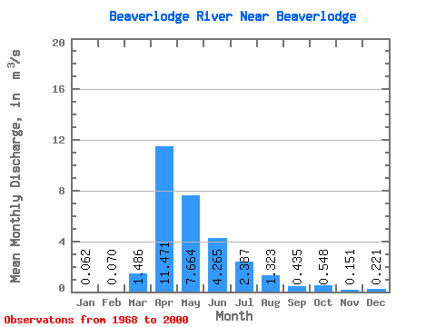
| Statistic | Jan | Feb | Mar | Apr | May | Jun | Jul | Aug | Sep | Oct | Nov | Dec | Annual |
|---|---|---|---|---|---|---|---|---|---|---|---|---|---|
| Mean | 0.06 | 0.07 | 1.49 | 11.47 | 7.66 | 4.26 | 2.39 | 1.32 | 0.43 | 0.55 | 0.15 | 0.22 | 1.82 |
| Standard Deviation | 0.09 | 0.09 | 2.01 | 10.31 | 9.22 | 5.83 | 4.59 | 3.55 | 0.83 | 0.99 | 0.22 | 0.42 | 1.32 |
| Min | 0.00 | 0.00 | 0.00 | 0.25 | 0.01 | 0.03 | 0.01 | 0.00 | 0.00 | 0.00 | 0.00 | 0.00 | 0.38 |
| Max | 0.20 | 0.22 | 6.55 | 38.60 | 39.60 | 26.10 | 21.40 | 15.20 | 3.55 | 3.72 | 0.57 | 1.22 | 3.88 |
| Coefficient of Variation | 1.42 | 1.28 | 1.35 | 0.90 | 1.20 | 1.37 | 1.92 | 2.69 | 1.90 | 1.80 | 1.44 | 1.92 | 0.73 |
 Return to R-Arctic Net Home Page