|
|
|||||||||||||||||
| Point ID: 747 | Downloads | Plots | Site Data | Code: 07GD001 |
|
|
|||||||||||||||||
| Download | |
|---|---|
| Site Descriptor Information | Site Time Series Data |
| Link to all available data | |
| View: | Time Series | All |
| Units: | m3/s |
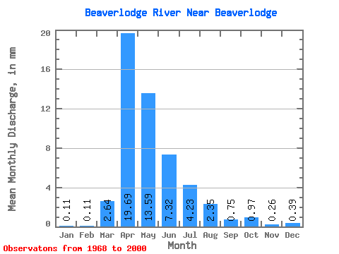
| Statistic | Jan | Feb | Mar | Apr | May | Jun | Jul | Aug | Sep | Oct | Nov | Dec | Annual |
|---|---|---|---|---|---|---|---|---|---|---|---|---|---|
| Mean | 0.10 | 0.11 | 2.47 | 18.47 | 12.75 | 6.87 | 3.97 | 2.20 | 0.70 | 0.91 | 0.24 | 0.37 | 35.77 |
| Standard Deviation | 0.15 | 0.14 | 3.34 | 16.59 | 15.34 | 9.38 | 7.64 | 5.91 | 1.33 | 1.65 | 0.35 | 0.71 | 25.98 |
| Min | 0.00 | 0.00 | 0.00 | 0.40 | 0.02 | 0.05 | 0.01 | 0.00 | 0.00 | 0.00 | 0.00 | 0.00 | 7.40 |
| Max | 0.33 | 0.33 | 10.89 | 62.14 | 65.87 | 42.02 | 35.60 | 25.28 | 5.71 | 6.19 | 0.92 | 2.03 | 75.96 |
| Coefficient of Variation | 1.42 | 1.28 | 1.35 | 0.90 | 1.20 | 1.37 | 1.92 | 2.69 | 1.90 | 1.80 | 1.44 | 1.92 | 0.73 |
 Return to R-Arctic Net Home Page