|
|
|||||||||||||||||
| Point ID: 7424 | Downloads | Plots | Site Data | Code: 70288 |
|
|
|||||||||||||||||
| Download | |
|---|---|
| Site Descriptor Information | Site Time Series Data |
| Link to all available data | |
| View: | Time Series | All |
| Units: | mm |
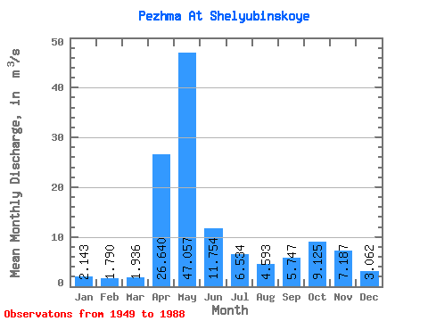
| Statistic | Jan | Feb | Mar | Apr | May | Jun | Jul | Aug | Sep | Oct | Nov | Dec | Annual |
|---|---|---|---|---|---|---|---|---|---|---|---|---|---|
| Mean | 2.14 | 1.79 | 1.94 | 26.64 | 47.06 | 11.75 | 6.53 | 4.59 | 5.75 | 9.12 | 7.19 | 3.06 | 10.74 |
| Standard Deviation | 1.11 | 1.01 | 0.83 | 17.68 | 24.55 | 9.38 | 5.02 | 3.57 | 5.01 | 7.29 | 5.87 | 1.77 | 2.95 |
| Min | 0.94 | 0.93 | 1.01 | 3.60 | 10.20 | 2.23 | 1.57 | 1.49 | 1.38 | 1.85 | 1.36 | 1.29 | 5.62 |
| Max | 6.61 | 6.84 | 5.17 | 82.00 | 103.00 | 51.10 | 21.70 | 16.80 | 21.30 | 28.20 | 28.00 | 11.00 | 17.28 |
| Coefficient of Variation | 0.52 | 0.56 | 0.43 | 0.66 | 0.52 | 0.80 | 0.77 | 0.78 | 0.87 | 0.80 | 0.82 | 0.58 | 0.28 |
 Return to R-Arctic Net Home Page