|
|
|||||||||||||||||
| Point ID: 7424 | Downloads | Plots | Site Data | Code: 70288 |
|
|
|||||||||||||||||
| Download | |
|---|---|
| Site Descriptor Information | Site Time Series Data |
| Link to all available data | |
| View: | Time Series | All |
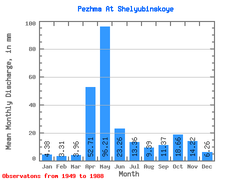
| Units: | m3/s |
| Statistic | Jan | Feb | Mar | Apr | May | Jun | Jul | Aug | Sep | Oct | Nov | Dec | Annual |
|---|---|---|---|---|---|---|---|---|---|---|---|---|---|
| Mean | 4.38 | 3.33 | 3.96 | 52.71 | 96.20 | 23.26 | 13.36 | 9.39 | 11.37 | 18.65 | 14.22 | 6.26 | 258.69 |
| Standard Deviation | 2.27 | 1.87 | 1.69 | 34.98 | 50.18 | 18.57 | 10.27 | 7.30 | 9.92 | 14.91 | 11.60 | 3.62 | 71.05 |
| Min | 1.92 | 1.73 | 2.06 | 7.12 | 20.85 | 4.41 | 3.21 | 3.05 | 2.73 | 3.78 | 2.69 | 2.64 | 135.34 |
| Max | 13.51 | 12.74 | 10.57 | 162.25 | 210.56 | 101.11 | 44.36 | 34.34 | 42.15 | 57.65 | 55.40 | 22.49 | 416.22 |
| Coefficient of Variation | 0.52 | 0.56 | 0.43 | 0.66 | 0.52 | 0.80 | 0.77 | 0.78 | 0.87 | 0.80 | 0.82 | 0.58 | 0.28 |
 Return to R-Arctic Net Home Page