|
|
|||||||||||||||||
| Point ID: 7404 | Downloads | Plots | Site Data | Code: 70231 |
|
|
|||||||||||||||||
| Download | |
|---|---|
| Site Descriptor Information | Site Time Series Data |
| Link to all available data | |
| View: | Time Series | All |
| Units: | mm |
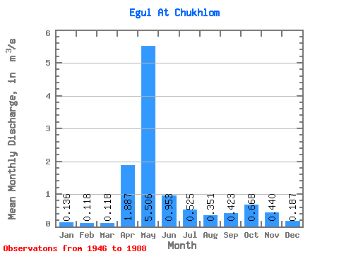
| Statistic | Jan | Feb | Mar | Apr | May | Jun | Jul | Aug | Sep | Oct | Nov | Dec | Annual |
|---|---|---|---|---|---|---|---|---|---|---|---|---|---|
| Mean | 0.14 | 0.12 | 0.12 | 1.89 | 5.51 | 0.95 | 0.53 | 0.35 | 0.42 | 0.67 | 0.44 | 0.19 | 0.94 |
| Standard Deviation | 0.07 | 0.06 | 0.05 | 1.51 | 2.57 | 0.61 | 0.64 | 0.43 | 0.59 | 0.54 | 0.37 | 0.14 | 0.24 |
| Min | 0.04 | 0.04 | 0.04 | 0.14 | 0.94 | 0.08 | 0.04 | 0.06 | 0.02 | 0.13 | 0.07 | 0.07 | 0.43 |
| Max | 0.36 | 0.33 | 0.24 | 6.02 | 9.74 | 2.87 | 3.49 | 1.79 | 3.63 | 2.39 | 1.54 | 0.81 | 1.48 |
| Coefficient of Variation | 0.55 | 0.53 | 0.39 | 0.80 | 0.47 | 0.64 | 1.22 | 1.23 | 1.40 | 0.81 | 0.84 | 0.74 | 0.26 |
 Return to R-Arctic Net Home Page