|
|
|||||||||||||||||
| Point ID: 7404 | Downloads | Plots | Site Data | Code: 70231 |
|
|
|||||||||||||||||
| Download | |
|---|---|
| Site Descriptor Information | Site Time Series Data |
| Link to all available data | |
| View: | Time Series | All |
| Units: | m3/s |
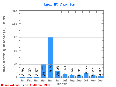
| Statistic | Jan | Feb | Mar | Apr | May | Jun | Jul | Aug | Sep | Oct | Nov | Dec | Annual |
|---|---|---|---|---|---|---|---|---|---|---|---|---|---|
| Mean | 2.96 | 2.33 | 2.57 | 39.76 | 119.88 | 20.09 | 11.43 | 7.64 | 8.92 | 14.54 | 9.27 | 4.07 | 241.29 |
| Standard Deviation | 1.62 | 1.24 | 1.01 | 31.88 | 55.94 | 12.91 | 13.91 | 9.40 | 12.52 | 11.72 | 7.77 | 3.00 | 62.65 |
| Min | 0.96 | 0.85 | 0.94 | 2.95 | 20.47 | 1.75 | 0.89 | 1.20 | 0.44 | 2.83 | 1.50 | 1.50 | 111.06 |
| Max | 7.84 | 6.55 | 5.22 | 126.86 | 212.06 | 60.48 | 75.99 | 38.97 | 76.50 | 52.04 | 32.45 | 17.64 | 378.89 |
| Coefficient of Variation | 0.55 | 0.53 | 0.39 | 0.80 | 0.47 | 0.64 | 1.22 | 1.23 | 1.40 | 0.81 | 0.84 | 0.74 | 0.26 |
 Return to R-Arctic Net Home Page