|
|
|||||||||||||||||
| Point ID: 7398 | Downloads | Plots | Site Data | Code: 70215 |
|
|
|||||||||||||||||
| Download | |
|---|---|
| Site Descriptor Information | Site Time Series Data |
| Link to all available data | |
| View: | Time Series | All |
| Units: | mm |
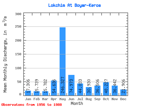
| Statistic | Jan | Feb | Mar | Apr | May | Jun | Jul | Aug | Sep | Oct | Nov | Dec | Annual |
|---|---|---|---|---|---|---|---|---|---|---|---|---|---|
| Mean | 17.31 | 15.74 | 15.78 | 54.64 | 246.33 | 74.97 | 44.03 | 30.93 | 36.51 | 48.23 | 36.44 | 21.91 | 53.57 |
| Standard Deviation | 2.75 | 2.12 | 1.87 | 46.83 | 76.39 | 30.88 | 21.42 | 15.67 | 24.75 | 21.88 | 16.34 | 6.39 | 9.79 |
| Min | 12.90 | 12.00 | 12.80 | 13.40 | 76.90 | 22.70 | 16.30 | 16.60 | 16.40 | 21.30 | 15.00 | 13.80 | 31.32 |
| Max | 23.40 | 20.00 | 19.70 | 231.00 | 411.00 | 145.00 | 106.00 | 94.40 | 161.00 | 108.00 | 94.10 | 46.50 | 71.23 |
| Coefficient of Variation | 0.16 | 0.14 | 0.12 | 0.86 | 0.31 | 0.41 | 0.49 | 0.51 | 0.68 | 0.45 | 0.45 | 0.29 | 0.18 |
 Return to R-Arctic Net Home Page