|
|
|||||||||||||||||
| Point ID: 7398 | Downloads | Plots | Site Data | Code: 70215 |
|
|
|||||||||||||||||
| Download | |
|---|---|
| Site Descriptor Information | Site Time Series Data |
| Link to all available data | |
| View: | Time Series | All |
| Units: | m3/s |
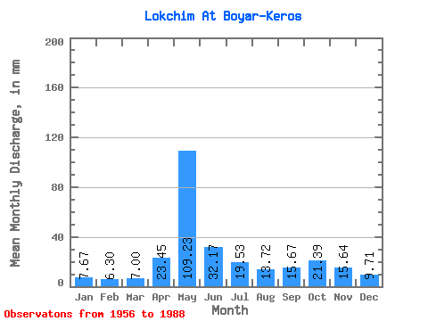
| Statistic | Jan | Feb | Mar | Apr | May | Jun | Jul | Aug | Sep | Oct | Nov | Dec | Annual |
|---|---|---|---|---|---|---|---|---|---|---|---|---|---|
| Mean | 7.67 | 6.36 | 7.00 | 23.45 | 109.22 | 32.17 | 19.52 | 13.71 | 15.67 | 21.38 | 15.64 | 9.71 | 279.90 |
| Standard Deviation | 1.22 | 0.86 | 0.83 | 20.10 | 33.87 | 13.25 | 9.50 | 6.95 | 10.62 | 9.70 | 7.01 | 2.83 | 51.15 |
| Min | 5.72 | 4.85 | 5.67 | 5.75 | 34.10 | 9.74 | 7.23 | 7.36 | 7.04 | 9.44 | 6.44 | 6.12 | 163.68 |
| Max | 10.38 | 8.08 | 8.73 | 99.13 | 182.23 | 62.23 | 47.00 | 41.85 | 69.09 | 47.88 | 40.38 | 20.62 | 372.21 |
| Coefficient of Variation | 0.16 | 0.14 | 0.12 | 0.86 | 0.31 | 0.41 | 0.49 | 0.51 | 0.68 | 0.45 | 0.45 | 0.29 | 0.18 |
 Return to R-Arctic Net Home Page