|
|
|||||||||||||||||
| Point ID: 7375 | Downloads | Plots | Site Data | Code: 70159 |
|
|
|||||||||||||||||
| Download | |
|---|---|
| Site Descriptor Information | Site Time Series Data |
| Link to all available data | |
| View: | Time Series | All |
| Units: | mm |
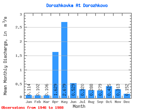
| Statistic | Jan | Feb | Mar | Apr | May | Jun | Jul | Aug | Sep | Oct | Nov | Dec | Annual |
|---|---|---|---|---|---|---|---|---|---|---|---|---|---|
| Mean | 0.11 | 0.10 | 0.11 | 1.63 | 2.68 | 0.53 | 0.32 | 0.29 | 0.28 | 0.42 | 0.31 | 0.15 | 0.58 |
| Standard Deviation | 0.04 | 0.03 | 0.04 | 0.99 | 1.51 | 0.46 | 0.29 | 0.47 | 0.41 | 0.47 | 0.28 | 0.07 | 0.19 |
| Min | 0.06 | 0.06 | 0.06 | 0.15 | 0.41 | 0.09 | 0.06 | 0.07 | 0.06 | 0.08 | 0.07 | 0.07 | 0.27 |
| Max | 0.20 | 0.18 | 0.25 | 4.12 | 6.20 | 2.13 | 1.22 | 2.17 | 2.39 | 2.53 | 1.70 | 0.37 | 1.19 |
| Coefficient of Variation | 0.33 | 0.29 | 0.36 | 0.61 | 0.56 | 0.87 | 0.89 | 1.63 | 1.46 | 1.11 | 0.91 | 0.45 | 0.33 |
 Return to R-Arctic Net Home Page