|
|
|||||||||||||||||
| Point ID: 7375 | Downloads | Plots | Site Data | Code: 70159 |
|
|
|||||||||||||||||
| Download | |
|---|---|
| Site Descriptor Information | Site Time Series Data |
| Link to all available data | |
| View: | Time Series | All |
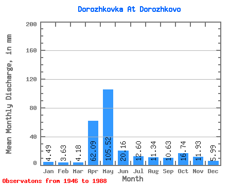
| Units: | m3/s |
| Statistic | Jan | Feb | Mar | Apr | May | Jun | Jul | Aug | Sep | Oct | Nov | Dec | Annual |
|---|---|---|---|---|---|---|---|---|---|---|---|---|---|
| Mean | 4.49 | 3.66 | 4.17 | 62.09 | 105.49 | 20.16 | 12.61 | 11.35 | 10.63 | 16.73 | 11.94 | 5.97 | 268.65 |
| Standard Deviation | 1.48 | 1.06 | 1.50 | 37.92 | 59.35 | 17.53 | 11.28 | 18.49 | 15.48 | 18.65 | 10.87 | 2.67 | 87.28 |
| Min | 2.28 | 2.08 | 2.48 | 5.72 | 16.15 | 3.54 | 2.48 | 2.68 | 2.40 | 3.07 | 2.67 | 2.84 | 123.88 |
| Max | 7.88 | 6.46 | 9.85 | 157.04 | 244.17 | 81.19 | 48.05 | 85.46 | 91.10 | 99.64 | 64.80 | 14.57 | 550.40 |
| Coefficient of Variation | 0.33 | 0.29 | 0.36 | 0.61 | 0.56 | 0.87 | 0.89 | 1.63 | 1.46 | 1.11 | 0.91 | 0.45 | 0.33 |
 Return to R-Arctic Net Home Page