|
|
|||||||||||||||||
| Point ID: 7369 | Downloads | Plots | Site Data | Code: 70150 |
|
|
|||||||||||||||||
| Download | |
|---|---|
| Site Descriptor Information | Site Time Series Data |
| Link to all available data | |
| View: | Time Series | All |
| Units: | mm |
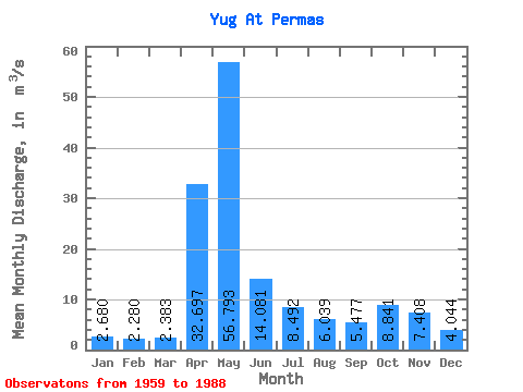
| Statistic | Jan | Feb | Mar | Apr | May | Jun | Jul | Aug | Sep | Oct | Nov | Dec | Annual |
|---|---|---|---|---|---|---|---|---|---|---|---|---|---|
| Mean | 2.68 | 2.28 | 2.38 | 32.70 | 56.79 | 14.08 | 8.49 | 6.04 | 5.48 | 8.84 | 7.41 | 4.04 | 12.64 |
| Standard Deviation | 0.87 | 0.50 | 0.49 | 21.32 | 30.20 | 13.46 | 8.12 | 7.74 | 4.25 | 7.10 | 4.81 | 2.67 | 3.50 |
| Min | 1.55 | 1.53 | 1.58 | 4.29 | 10.10 | 2.53 | 1.63 | 1.82 | 1.91 | 2.14 | 1.96 | 1.39 | 7.60 |
| Max | 5.18 | 3.71 | 3.92 | 85.80 | 136.00 | 61.10 | 38.90 | 34.70 | 16.30 | 25.10 | 21.10 | 14.90 | 19.52 |
| Coefficient of Variation | 0.32 | 0.22 | 0.21 | 0.65 | 0.53 | 0.96 | 0.96 | 1.28 | 0.78 | 0.80 | 0.65 | 0.66 | 0.28 |
 Return to R-Arctic Net Home Page