|
|
|||||||||||||||||
| Point ID: 7369 | Downloads | Plots | Site Data | Code: 70150 |
|
|
|||||||||||||||||
| Download | |
|---|---|
| Site Descriptor Information | Site Time Series Data |
| Link to all available data | |
| View: | Time Series | All |
| Units: | m3/s |
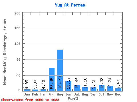
| Statistic | Jan | Feb | Mar | Apr | May | Jun | Jul | Aug | Sep | Oct | Nov | Dec | Annual |
|---|---|---|---|---|---|---|---|---|---|---|---|---|---|
| Mean | 4.95 | 3.84 | 4.40 | 58.45 | 104.89 | 25.17 | 15.69 | 11.15 | 9.79 | 16.33 | 13.24 | 7.47 | 275.08 |
| Standard Deviation | 1.60 | 0.84 | 0.91 | 38.11 | 55.79 | 24.06 | 15.00 | 14.30 | 7.59 | 13.11 | 8.61 | 4.92 | 76.12 |
| Min | 2.86 | 2.58 | 2.92 | 7.67 | 18.65 | 4.52 | 3.01 | 3.36 | 3.41 | 3.95 | 3.50 | 2.57 | 165.49 |
| Max | 9.57 | 6.24 | 7.24 | 153.38 | 251.18 | 109.22 | 71.84 | 64.09 | 29.14 | 46.36 | 37.72 | 27.52 | 424.86 |
| Coefficient of Variation | 0.32 | 0.22 | 0.21 | 0.65 | 0.53 | 0.96 | 0.96 | 1.28 | 0.78 | 0.80 | 0.65 | 0.66 | 0.28 |
 Return to R-Arctic Net Home Page