|
|
|||||||||||||||||
| Point ID: 735 | Downloads | Plots | Site Data | Code: 07FD013 |
|
|
|||||||||||||||||
| Download | |
|---|---|
| Site Descriptor Information | Site Time Series Data |
| Link to all available data | |
| View: | Time Series | All |
| Units: | mm |
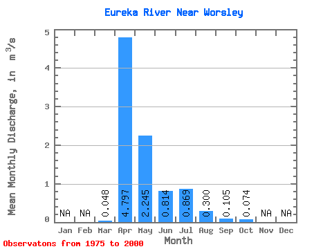
| Statistic | Jan | Feb | Mar | Apr | May | Jun | Jul | Aug | Sep | Oct | Nov | Dec | Annual |
|---|---|---|---|---|---|---|---|---|---|---|---|---|---|
| Mean | 0.05 | 4.80 | 2.25 | 0.81 | 0.87 | 0.30 | 0.10 | 0.07 | |||||
| Standard Deviation | 0.15 | 4.18 | 2.33 | 1.20 | 2.30 | 0.71 | 0.29 | 0.12 | |||||
| Min | 0.00 | 0.00 | 0.01 | 0.00 | 0.00 | 0.00 | 0.00 | 0.00 | |||||
| Max | 0.74 | 16.10 | 7.77 | 5.32 | 11.50 | 3.14 | 1.35 | 0.35 | |||||
| Coefficient of Variation | 3.17 | 0.87 | 1.04 | 1.48 | 2.65 | 2.37 | 2.79 | 1.56 |
 Return to R-Arctic Net Home Page