|
|
|||||||||||||||||
| Point ID: 735 | Downloads | Plots | Site Data | Code: 07FD013 |
|
|
|||||||||||||||||
| Download | |
|---|---|
| Site Descriptor Information | Site Time Series Data |
| Link to all available data | |
| View: | Time Series | All |
| Units: | m3/s |
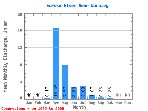
| Statistic | Jan | Feb | Mar | Apr | May | Jun | Jul | Aug | Sep | Oct | Nov | Dec | Annual |
|---|---|---|---|---|---|---|---|---|---|---|---|---|---|
| Mean | 0.17 | 16.49 | 7.97 | 2.80 | 3.09 | 1.06 | 0.36 | 0.26 | |||||
| Standard Deviation | 0.54 | 14.38 | 8.28 | 4.13 | 8.18 | 2.52 | 1.01 | 0.41 | |||||
| Min | 0.00 | 0.00 | 0.03 | 0.00 | 0.00 | 0.00 | 0.00 | 0.00 | |||||
| Max | 2.64 | 55.35 | 27.60 | 18.29 | 40.84 | 11.15 | 4.64 | 1.26 | |||||
| Coefficient of Variation | 3.17 | 0.87 | 1.04 | 1.48 | 2.65 | 2.37 | 2.79 | 1.56 |
 Return to R-Arctic Net Home Page