|
|
|||||||||||||||||
| Point ID: 7343 | Downloads | Plots | Site Data | Code: 70031 |
|
|
|||||||||||||||||
| Download | |
|---|---|
| Site Descriptor Information | Site Time Series Data |
| Link to all available data | |
| View: | Time Series | All |
| Units: | mm |
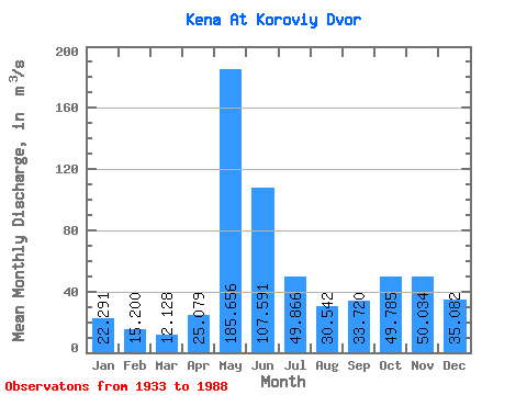
| Statistic | Jan | Feb | Mar | Apr | May | Jun | Jul | Aug | Sep | Oct | Nov | Dec | Annual |
|---|---|---|---|---|---|---|---|---|---|---|---|---|---|
| Mean | 22.29 | 15.20 | 12.13 | 25.08 | 185.66 | 107.59 | 49.87 | 30.54 | 33.72 | 49.78 | 50.03 | 35.08 | 51.30 |
| Standard Deviation | 9.60 | 5.37 | 3.80 | 23.86 | 59.65 | 42.01 | 22.44 | 20.38 | 28.34 | 35.06 | 30.52 | 17.19 | 13.47 |
| Min | 5.67 | 5.43 | 4.82 | 4.46 | 50.80 | 41.30 | 19.60 | 9.06 | 6.86 | 6.70 | 7.49 | 6.52 | 24.72 |
| Max | 47.60 | 30.80 | 23.40 | 130.00 | 288.00 | 211.00 | 120.00 | 95.00 | 127.00 | 129.00 | 113.00 | 88.50 | 81.85 |
| Coefficient of Variation | 0.43 | 0.35 | 0.31 | 0.95 | 0.32 | 0.39 | 0.45 | 0.67 | 0.84 | 0.70 | 0.61 | 0.49 | 0.26 |
 Return to R-Arctic Net Home Page