|
|
|||||||||||||||||
| Point ID: 7343 | Downloads | Plots | Site Data | Code: 70031 |
|
|
|||||||||||||||||
| Download | |
|---|---|
| Site Descriptor Information | Site Time Series Data |
| Link to all available data | |
| View: | Time Series | All |
| Units: | m3/s |
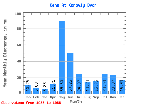
| Statistic | Jan | Feb | Mar | Apr | May | Jun | Jul | Aug | Sep | Oct | Nov | Dec | Annual |
|---|---|---|---|---|---|---|---|---|---|---|---|---|---|
| Mean | 10.76 | 6.68 | 5.85 | 11.71 | 89.58 | 50.25 | 24.06 | 14.74 | 15.75 | 24.02 | 23.37 | 16.93 | 291.69 |
| Standard Deviation | 4.63 | 2.36 | 1.83 | 11.14 | 28.78 | 19.62 | 10.83 | 9.84 | 13.23 | 16.92 | 14.25 | 8.30 | 76.58 |
| Min | 2.74 | 2.39 | 2.33 | 2.08 | 24.51 | 19.29 | 9.46 | 4.37 | 3.20 | 3.23 | 3.50 | 3.15 | 140.57 |
| Max | 22.97 | 13.54 | 11.29 | 60.71 | 138.97 | 98.54 | 57.90 | 45.84 | 59.31 | 62.24 | 52.77 | 42.70 | 465.44 |
| Coefficient of Variation | 0.43 | 0.35 | 0.31 | 0.95 | 0.32 | 0.39 | 0.45 | 0.67 | 0.84 | 0.70 | 0.61 | 0.49 | 0.26 |
 Return to R-Arctic Net Home Page