|
|
|||||||||||||||||
| Point ID: 7340 | Downloads | Plots | Site Data | Code: 70023 |
|
|
|||||||||||||||||
| Download | |
|---|---|
| Site Descriptor Information | Site Time Series Data |
| Link to all available data | |
| View: | Time Series | All |
| Units: | mm |
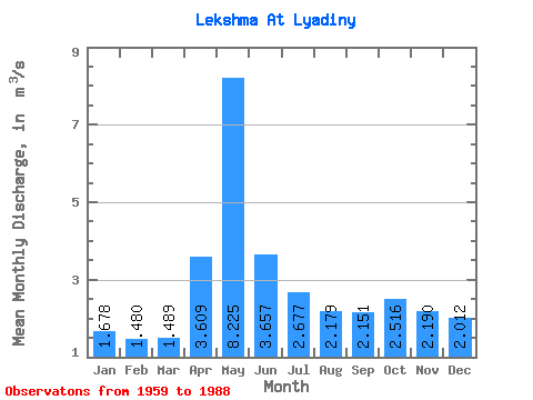
| Statistic | Jan | Feb | Mar | Apr | May | Jun | Jul | Aug | Sep | Oct | Nov | Dec | Annual |
|---|---|---|---|---|---|---|---|---|---|---|---|---|---|
| Mean | 1.68 | 1.48 | 1.49 | 3.61 | 8.22 | 3.66 | 2.68 | 2.18 | 2.15 | 2.52 | 2.19 | 2.01 | 2.83 |
| Standard Deviation | 0.61 | 0.47 | 0.39 | 1.99 | 2.67 | 1.65 | 1.26 | 1.38 | 1.23 | 1.37 | 1.02 | 0.85 | 0.60 |
| Min | 0.59 | 0.57 | 0.72 | 1.25 | 3.47 | 0.97 | 0.78 | 0.43 | 0.56 | 0.25 | 0.33 | 0.62 | 1.63 |
| Max | 3.06 | 2.59 | 2.29 | 9.16 | 14.60 | 6.48 | 5.48 | 5.19 | 5.02 | 6.42 | 4.28 | 4.90 | 4.08 |
| Coefficient of Variation | 0.36 | 0.32 | 0.26 | 0.55 | 0.32 | 0.45 | 0.47 | 0.64 | 0.57 | 0.55 | 0.47 | 0.42 | 0.21 |
 Return to R-Arctic Net Home Page