|
|
|||||||||||||||||
| Point ID: 7340 | Downloads | Plots | Site Data | Code: 70023 |
|
|
|||||||||||||||||
| Download | |
|---|---|
| Site Descriptor Information | Site Time Series Data |
| Link to all available data | |
| View: | Time Series | All |
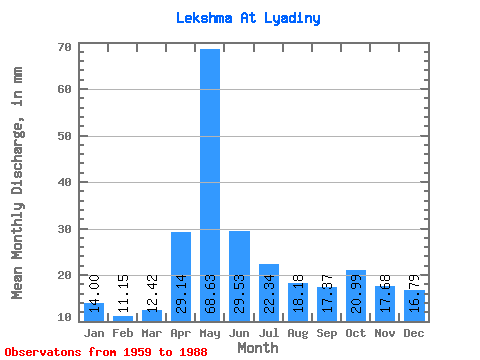
| Units: | m3/s |
| Statistic | Jan | Feb | Mar | Apr | May | Jun | Jul | Aug | Sep | Oct | Nov | Dec | Annual |
|---|---|---|---|---|---|---|---|---|---|---|---|---|---|
| Mean | 14.00 | 11.25 | 12.42 | 29.14 | 68.62 | 29.53 | 22.33 | 18.18 | 17.37 | 20.99 | 17.68 | 16.79 | 278.21 |
| Standard Deviation | 5.09 | 3.61 | 3.23 | 16.10 | 22.25 | 13.34 | 10.52 | 11.54 | 9.95 | 11.44 | 8.26 | 7.12 | 59.48 |
| Min | 4.92 | 4.33 | 6.01 | 10.09 | 28.95 | 7.83 | 6.51 | 3.59 | 4.52 | 2.09 | 2.67 | 5.17 | 160.26 |
| Max | 25.53 | 19.69 | 19.11 | 73.97 | 121.80 | 52.32 | 45.72 | 43.30 | 40.53 | 53.56 | 34.56 | 40.88 | 400.89 |
| Coefficient of Variation | 0.36 | 0.32 | 0.26 | 0.55 | 0.32 | 0.45 | 0.47 | 0.64 | 0.57 | 0.55 | 0.47 | 0.42 | 0.21 |
 Return to R-Arctic Net Home Page