|
|
|||||||||||||||||
| Point ID: 7333 | Downloads | Plots | Site Data | Code: 70002 |
|
|
|||||||||||||||||
| Download | |
|---|---|
| Site Descriptor Information | Site Time Series Data |
| Link to all available data | |
| View: | Time Series | All |
| Units: | mm |
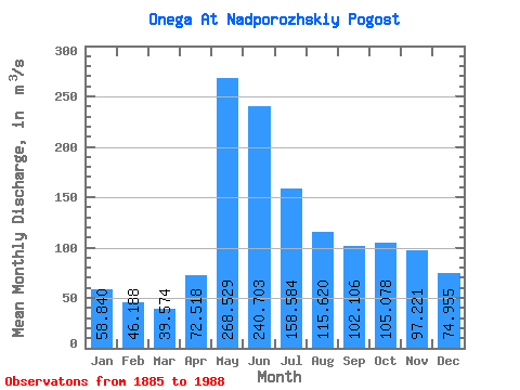
| Statistic | Jan | Feb | Mar | Apr | May | Jun | Jul | Aug | Sep | Oct | Nov | Dec | Annual |
|---|---|---|---|---|---|---|---|---|---|---|---|---|---|
| Mean | 58.84 | 46.19 | 39.57 | 72.52 | 268.53 | 240.70 | 158.58 | 115.62 | 102.11 | 105.08 | 97.22 | 74.95 | 112.57 |
| Standard Deviation | 28.34 | 20.60 | 16.52 | 39.56 | 84.74 | 91.56 | 60.52 | 52.46 | 50.69 | 52.59 | 53.68 | 37.86 | 31.58 |
| Min | 17.80 | 14.80 | 12.00 | 13.60 | 100.00 | 102.00 | 68.70 | 49.40 | 34.40 | 36.50 | 30.50 | 20.20 | 52.33 |
| Max | 150.00 | 102.00 | 85.30 | 236.00 | 568.00 | 707.00 | 412.00 | 319.00 | 278.00 | 246.00 | 266.00 | 236.00 | 234.08 |
| Coefficient of Variation | 0.48 | 0.45 | 0.42 | 0.55 | 0.32 | 0.38 | 0.38 | 0.45 | 0.50 | 0.50 | 0.55 | 0.51 | 0.28 |
 Return to R-Arctic Net Home Page