|
|
|||||||||||||||||
| Point ID: 7333 | Downloads | Plots | Site Data | Code: 70002 |
|
|
|||||||||||||||||
| Download | |
|---|---|
| Site Descriptor Information | Site Time Series Data |
| Link to all available data | |
| View: | Time Series | All |
| Units: | m3/s |
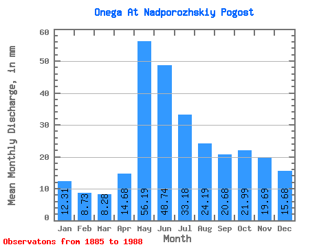
| Statistic | Jan | Feb | Mar | Apr | May | Jun | Jul | Aug | Sep | Oct | Nov | Dec | Annual |
|---|---|---|---|---|---|---|---|---|---|---|---|---|---|
| Mean | 12.31 | 8.80 | 8.28 | 14.69 | 56.18 | 48.74 | 33.18 | 24.19 | 20.68 | 21.98 | 19.69 | 15.68 | 277.55 |
| Standard Deviation | 5.93 | 3.93 | 3.46 | 8.01 | 17.73 | 18.54 | 12.66 | 10.98 | 10.26 | 11.00 | 10.87 | 7.92 | 77.85 |
| Min | 3.72 | 2.82 | 2.51 | 2.75 | 20.92 | 20.66 | 14.37 | 10.34 | 6.97 | 7.64 | 6.18 | 4.23 | 129.01 |
| Max | 31.38 | 19.44 | 17.85 | 47.79 | 118.84 | 143.17 | 86.20 | 66.74 | 56.30 | 51.47 | 53.87 | 49.38 | 577.16 |
| Coefficient of Variation | 0.48 | 0.45 | 0.42 | 0.55 | 0.32 | 0.38 | 0.38 | 0.45 | 0.50 | 0.50 | 0.55 | 0.51 | 0.28 |
 Return to R-Arctic Net Home Page