|
|
|||||||||||||||||
| Point ID: 7307 | Downloads | Plots | Site Data | Code: 49097 |
|
|
|||||||||||||||||
| Download | |
|---|---|
| Site Descriptor Information | Site Time Series Data |
| Link to all available data | |
| View: | Time Series | All |
| Units: | mm |
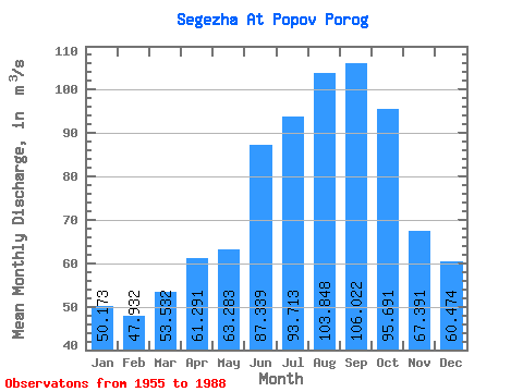
| Statistic | Jan | Feb | Mar | Apr | May | Jun | Jul | Aug | Sep | Oct | Nov | Dec | Annual |
|---|---|---|---|---|---|---|---|---|---|---|---|---|---|
| Mean | 50.17 | 47.93 | 53.53 | 61.29 | 63.28 | 87.34 | 93.71 | 103.85 | 106.02 | 95.69 | 67.39 | 60.47 | 73.67 |
| Standard Deviation | 23.91 | 24.59 | 31.34 | 34.88 | 23.54 | 32.72 | 37.56 | 38.80 | 36.22 | 34.73 | 42.20 | 36.07 | 15.85 |
| Min | 25.00 | 25.00 | 25.00 | 25.00 | 26.90 | 57.90 | 56.10 | 58.00 | 60.00 | 45.90 | 25.00 | 25.00 | 48.44 |
| Max | 102.00 | 98.20 | 125.00 | 125.00 | 124.00 | 168.00 | 177.00 | 180.00 | 170.00 | 181.00 | 188.00 | 145.00 | 100.03 |
| Coefficient of Variation | 0.48 | 0.51 | 0.58 | 0.57 | 0.37 | 0.38 | 0.40 | 0.37 | 0.34 | 0.36 | 0.63 | 0.60 | 0.21 |
 Return to R-Arctic Net Home Page