|
|
|||||||||||||||||
| Point ID: 7307 | Downloads | Plots | Site Data | Code: 49097 |
|
|
|||||||||||||||||
| Download | |
|---|---|
| Site Descriptor Information | Site Time Series Data |
| Link to all available data | |
| View: | Time Series | All |
| Units: | m3/s |
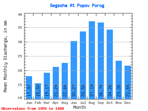
| Statistic | Jan | Feb | Mar | Apr | May | Jun | Jul | Aug | Sep | Oct | Nov | Dec | Annual |
|---|---|---|---|---|---|---|---|---|---|---|---|---|---|
| Mean | 17.96 | 15.64 | 19.17 | 21.24 | 22.66 | 30.27 | 33.55 | 37.18 | 36.74 | 34.26 | 23.35 | 21.65 | 310.84 |
| Standard Deviation | 8.56 | 8.02 | 11.22 | 12.09 | 8.43 | 11.34 | 13.45 | 13.89 | 12.55 | 12.43 | 14.62 | 12.91 | 66.86 |
| Min | 8.95 | 8.15 | 8.95 | 8.66 | 9.63 | 20.06 | 20.09 | 20.77 | 20.79 | 16.43 | 8.66 | 8.95 | 204.39 |
| Max | 36.52 | 32.03 | 44.75 | 43.32 | 44.40 | 58.22 | 63.37 | 64.44 | 58.91 | 64.80 | 65.15 | 51.91 | 422.03 |
| Coefficient of Variation | 0.48 | 0.51 | 0.58 | 0.57 | 0.37 | 0.38 | 0.40 | 0.37 | 0.34 | 0.36 | 0.63 | 0.60 | 0.21 |
 Return to R-Arctic Net Home Page