|
|
|||||||||||||||||
| Point ID: 729 | Downloads | Plots | Site Data | Code: 07FD003 |
|
|
|||||||||||||||||
| Download | |
|---|---|
| Site Descriptor Information | Site Time Series Data |
| Link to all available data | |
| View: | Time Series | All |
| Units: | mm |
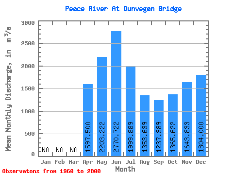
| Statistic | Jan | Feb | Mar | Apr | May | Jun | Jul | Aug | Sep | Oct | Nov | Dec | Annual |
|---|---|---|---|---|---|---|---|---|---|---|---|---|---|
| Mean | 1597.50 | 2203.22 | 2770.72 | 1999.89 | 1353.64 | 1237.39 | 1365.62 | 1643.83 | 1804.00 | ||||
| Standard Deviation | 283.94 | 812.75 | 1878.67 | 1277.87 | 756.92 | 364.59 | 292.32 | 384.60 | 197.69 | ||||
| Min | 1200.00 | 836.00 | 996.00 | 674.00 | 351.00 | 335.00 | 426.00 | 923.00 | 1490.00 | ||||
| Max | 1830.00 | 4260.00 | 8820.00 | 6410.00 | 3560.00 | 2300.00 | 1910.00 | 2030.00 | 2010.00 | ||||
| Coefficient of Variation | 0.18 | 0.37 | 0.68 | 0.64 | 0.56 | 0.29 | 0.21 | 0.23 | 0.11 |
 Return to R-Arctic Net Home Page