|
|
|||||||||||||||||
| Point ID: 729 | Downloads | Plots | Site Data | Code: 07FD003 |
|
|
|||||||||||||||||
| Download | |
|---|---|
| Site Descriptor Information | Site Time Series Data |
| Link to all available data | |
| View: | Time Series | All |
| Units: | m3/s |
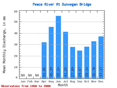
| Statistic | Jan | Feb | Mar | Apr | May | Jun | Jul | Aug | Sep | Oct | Nov | Dec | Annual |
|---|---|---|---|---|---|---|---|---|---|---|---|---|---|
| Mean | 31.85 | 45.39 | 55.24 | 41.20 | 27.89 | 24.67 | 28.13 | 32.78 | 37.16 | ||||
| Standard Deviation | 5.66 | 16.74 | 37.46 | 26.32 | 15.59 | 7.27 | 6.02 | 7.67 | 4.07 | ||||
| Min | 23.93 | 17.22 | 19.86 | 13.88 | 7.23 | 6.68 | 8.78 | 18.40 | 30.69 | ||||
| Max | 36.49 | 87.76 | 175.86 | 132.05 | 73.34 | 45.86 | 39.35 | 40.48 | 41.41 | ||||
| Coefficient of Variation | 0.18 | 0.37 | 0.68 | 0.64 | 0.56 | 0.29 | 0.21 | 0.23 | 0.11 |
 Return to R-Arctic Net Home Page