|
|
|||||||||||||||||
| Point ID: 7287 | Downloads | Plots | Site Data | Code: 49049 |
|
|
|||||||||||||||||
| Download | |
|---|---|
| Site Descriptor Information | Site Time Series Data |
| Link to all available data | |
| View: | Time Series | All |
| Units: | mm |
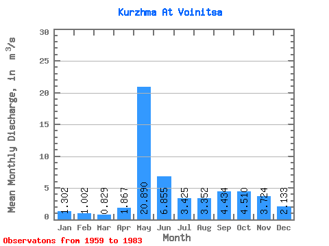
| Statistic | Jan | Feb | Mar | Apr | May | Jun | Jul | Aug | Sep | Oct | Nov | Dec | Annual |
|---|---|---|---|---|---|---|---|---|---|---|---|---|---|
| Mean | 1.30 | 1.00 | 0.83 | 1.87 | 20.89 | 6.86 | 3.42 | 3.35 | 4.43 | 4.51 | 3.72 | 2.13 | 4.59 |
| Standard Deviation | 0.54 | 0.38 | 0.22 | 1.73 | 5.87 | 2.81 | 2.39 | 3.05 | 2.91 | 1.95 | 1.73 | 0.90 | 1.01 |
| Min | 0.61 | 0.53 | 0.52 | 0.56 | 9.37 | 2.64 | 1.07 | 0.78 | 1.15 | 0.99 | 1.46 | 0.58 | 2.62 |
| Max | 2.93 | 2.10 | 1.40 | 7.39 | 31.10 | 13.40 | 9.45 | 12.10 | 10.60 | 8.78 | 8.91 | 4.63 | 6.23 |
| Coefficient of Variation | 0.41 | 0.37 | 0.27 | 0.93 | 0.28 | 0.41 | 0.70 | 0.91 | 0.66 | 0.43 | 0.47 | 0.42 | 0.22 |
 Return to R-Arctic Net Home Page