|
|
|||||||||||||||||
| Point ID: 7287 | Downloads | Plots | Site Data | Code: 49049 |
|
|
|||||||||||||||||
| Download | |
|---|---|
| Site Descriptor Information | Site Time Series Data |
| Link to all available data | |
| View: | Time Series | All |
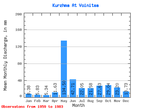
| Units: | m3/s |
| Statistic | Jan | Feb | Mar | Apr | May | Jun | Jul | Aug | Sep | Oct | Nov | Dec | Annual |
|---|---|---|---|---|---|---|---|---|---|---|---|---|---|
| Mean | 8.38 | 5.88 | 5.33 | 11.63 | 134.48 | 42.71 | 22.05 | 21.58 | 27.63 | 29.03 | 23.20 | 13.73 | 348.53 |
| Standard Deviation | 3.47 | 2.20 | 1.43 | 10.77 | 37.76 | 17.48 | 15.40 | 19.66 | 18.13 | 12.57 | 10.80 | 5.78 | 76.59 |
| Min | 3.93 | 3.11 | 3.35 | 3.49 | 60.32 | 16.45 | 6.89 | 5.02 | 7.17 | 6.37 | 9.10 | 3.73 | 198.39 |
| Max | 18.86 | 12.32 | 9.01 | 46.05 | 200.21 | 83.49 | 60.83 | 77.89 | 66.05 | 56.52 | 55.52 | 29.81 | 472.83 |
| Coefficient of Variation | 0.41 | 0.37 | 0.27 | 0.93 | 0.28 | 0.41 | 0.70 | 0.91 | 0.66 | 0.43 | 0.47 | 0.42 | 0.22 |
 Return to R-Arctic Net Home Page