|
|
|||||||||||||||||
| Point ID: 7264 | Downloads | Plots | Site Data | Code: 49001 |
|
|
|||||||||||||||||
| Download | |
|---|---|
| Site Descriptor Information | Site Time Series Data |
| Link to all available data | |
| View: | Time Series | All |
| Units: | mm |
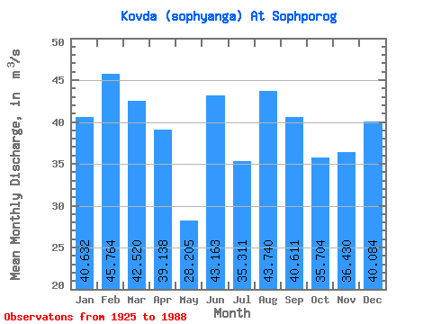
| Statistic | Jan | Feb | Mar | Apr | May | Jun | Jul | Aug | Sep | Oct | Nov | Dec | Annual |
|---|---|---|---|---|---|---|---|---|---|---|---|---|---|
| Mean | 40.63 | 45.76 | 42.52 | 39.14 | 28.20 | 43.16 | 35.31 | 43.74 | 40.61 | 35.70 | 36.43 | 40.08 | 33.71 |
| Standard Deviation | 24.87 | 32.26 | 31.32 | 25.80 | 16.27 | 22.01 | 14.68 | 17.02 | 24.33 | 20.24 | 20.51 | 22.05 | 14.01 |
| Min | 17.00 | 16.10 | 14.40 | 15.90 | 0.40 | 25.30 | 0.75 | 24.00 | 5.39 | 10.10 | 4.41 | 17.10 | 21.72 |
| Max | 91.20 | 98.40 | 106.00 | 101.00 | 77.20 | 110.00 | 73.20 | 77.70 | 110.00 | 98.70 | 86.20 | 83.60 | 65.69 |
| Coefficient of Variation | 0.61 | 0.70 | 0.74 | 0.66 | 0.58 | 0.51 | 0.42 | 0.39 | 0.60 | 0.57 | 0.56 | 0.55 | 0.42 |
 Return to R-Arctic Net Home Page