|
|
|||||||||||||||||
| Point ID: 7264 | Downloads | Plots | Site Data | Code: 49001 |
|
|
|||||||||||||||||
| Download | |
|---|---|
| Site Descriptor Information | Site Time Series Data |
| Link to all available data | |
| View: | Time Series | All |
| Units: | m3/s |
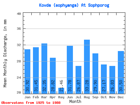
| Statistic | Jan | Feb | Mar | Apr | May | Jun | Jul | Aug | Sep | Oct | Nov | Dec | Annual |
|---|---|---|---|---|---|---|---|---|---|---|---|---|---|
| Mean | 30.91 | 31.72 | 32.35 | 28.82 | 21.46 | 31.78 | 26.86 | 33.28 | 29.91 | 27.16 | 26.82 | 30.50 | 302.27 |
| Standard Deviation | 18.92 | 22.36 | 23.83 | 19.00 | 12.38 | 16.21 | 11.16 | 12.95 | 17.92 | 15.40 | 15.10 | 16.78 | 125.59 |
| Min | 12.93 | 11.16 | 10.96 | 11.71 | 0.30 | 18.63 | 0.57 | 18.26 | 3.97 | 7.68 | 3.25 | 13.01 | 194.71 |
| Max | 69.39 | 68.21 | 80.64 | 74.37 | 58.73 | 81.00 | 55.69 | 59.11 | 81.00 | 75.09 | 63.48 | 63.60 | 588.99 |
| Coefficient of Variation | 0.61 | 0.70 | 0.74 | 0.66 | 0.58 | 0.51 | 0.42 | 0.39 | 0.60 | 0.57 | 0.56 | 0.55 | 0.42 |
 Return to R-Arctic Net Home Page