|
|
|||||||||||||||||
| Point ID: 7263 | Downloads | Plots | Site Data | Other Close Sites | Code: 12615 |
|
|
|||||||||||||||||
| Download | |
|---|---|
| Site Descriptor Information | Site Time Series Data |
| Link to all available data | |
| View: | Time Series | All |
| Units: | mm |
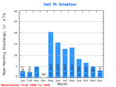
| Statistic | Jan | Feb | Mar | Apr | May | Jun | Jul | Aug | Sep | Oct | Nov | Dec | Annual |
|---|---|---|---|---|---|---|---|---|---|---|---|---|---|
| Mean | 2.87 | 2.55 | 4.73 | 20.36 | 15.64 | 12.80 | 13.36 | 8.38 | 6.62 | 4.96 | 3.20 | ||
| Standard Deviation | 1.14 | 0.92 | 1.76 | 8.49 | 4.10 | 8.98 | 11.88 | 6.42 | 1.65 | 2.08 | 0.84 | ||
| Min | 1.70 | 1.00 | 2.80 | 11.00 | 11.70 | 4.50 | 4.30 | 3.60 | 5.30 | 3.00 | 2.50 | ||
| Max | 4.70 | 3.70 | 7.30 | 29.60 | 21.50 | 28.00 | 34.00 | 19.40 | 9.00 | 8.20 | 4.60 | ||
| Coefficient of Variation | 0.40 | 0.36 | 0.37 | 0.42 | 0.26 | 0.70 | 0.89 | 0.77 | 0.25 | 0.42 | 0.26 |
| Other Close Sites | ||||||
|---|---|---|---|---|---|---|
| PointID | Latitude | Longitude | Drainage Area | Source | Name | |
| 7182 | "Iset' At Kataisk" | 56.28 | -1701927 | SHI | 386.00 | |
 Return to R-Arctic Net Home Page