|
|
|||||||||||||||||
| Point ID: 7182 | Downloads | Plots | Site Data | Other Close Sites | Code: 12123 |
|
|
|||||||||||||||||
| Download | |
|---|---|
| Site Descriptor Information | Site Time Series Data |
| Link to all available data | |
| View: | Time Series | All |
| Units: | mm |
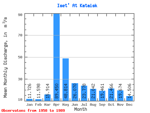
| Statistic | Jan | Feb | Mar | Apr | May | Jun | Jul | Aug | Sep | Oct | Nov | Dec | Annual |
|---|---|---|---|---|---|---|---|---|---|---|---|---|---|
| Mean | 11.73 | 11.60 | 15.91 | 89.45 | 48.81 | 26.07 | 23.78 | 21.04 | 19.46 | 21.47 | 19.67 | 14.51 | 27.50 |
| Standard Deviation | 6.71 | 7.01 | 9.96 | 48.26 | 34.25 | 10.91 | 14.61 | 12.05 | 12.82 | 16.45 | 14.72 | 8.26 | 11.91 |
| Min | 2.38 | 2.14 | 4.82 | 15.40 | 9.63 | 9.24 | 5.97 | 5.16 | 5.69 | 6.47 | 4.65 | 5.59 | 10.33 |
| Max | 32.60 | 37.50 | 42.70 | 204.00 | 159.00 | 45.30 | 70.80 | 55.70 | 77.40 | 85.50 | 78.10 | 38.30 | 66.15 |
| Coefficient of Variation | 0.57 | 0.60 | 0.63 | 0.54 | 0.70 | 0.42 | 0.61 | 0.57 | 0.66 | 0.77 | 0.75 | 0.57 | 0.43 |
| Other Close Sites | ||||||
|---|---|---|---|---|---|---|
| PointID | Latitude | Longitude | Drainage Area | Source | Name | |
| 7263 | "Iset At Dolmatovo" | 56.25 | -1683884 | SHI | 358.00 | |
 Return to R-Arctic Net Home Page