|
|
|||||||||||||||||
| Point ID: 7239 | Downloads | Plots | Site Data | Code: 12422 |
|
|
|||||||||||||||||
| Download | |
|---|---|
| Site Descriptor Information | Site Time Series Data |
| Link to all available data | |
| View: | Time Series | All |
| Units: | mm |
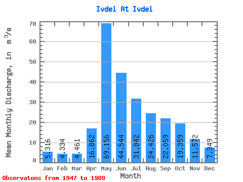
| Statistic | Jan | Feb | Mar | Apr | May | Jun | Jul | Aug | Sep | Oct | Nov | Dec | Annual |
|---|---|---|---|---|---|---|---|---|---|---|---|---|---|
| Mean | 5.32 | 4.33 | 4.46 | 16.86 | 69.16 | 44.54 | 31.84 | 24.43 | 22.06 | 19.36 | 11.57 | 7.35 | 21.77 |
| Standard Deviation | 1.82 | 1.28 | 1.26 | 12.68 | 27.46 | 24.50 | 24.58 | 15.69 | 15.35 | 8.73 | 4.98 | 4.38 | 6.30 |
| Min | 2.25 | 2.15 | 2.40 | 1.87 | 22.10 | 14.30 | 10.20 | 7.07 | 0.21 | 7.23 | 3.41 | 2.03 | 12.91 |
| Max | 11.30 | 9.12 | 8.21 | 54.80 | 137.00 | 109.00 | 117.00 | 73.30 | 87.00 | 39.40 | 29.10 | 30.10 | 37.47 |
| Coefficient of Variation | 0.34 | 0.29 | 0.28 | 0.75 | 0.40 | 0.55 | 0.77 | 0.64 | 0.70 | 0.45 | 0.43 | 0.59 | 0.29 |
 Return to R-Arctic Net Home Page