|
|
|||||||||||||||||
| Point ID: 7239 | Downloads | Plots | Site Data | Code: 12422 |
|
|
|||||||||||||||||
| Download | |
|---|---|
| Site Descriptor Information | Site Time Series Data |
| Link to all available data | |
| View: | Time Series | All |
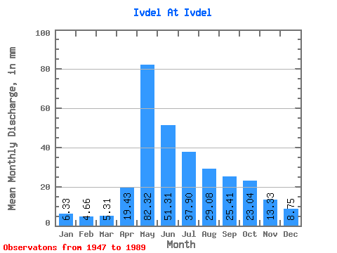
| Units: | m3/s |
| Statistic | Jan | Feb | Mar | Apr | May | Jun | Jul | Aug | Sep | Oct | Nov | Dec | Annual |
|---|---|---|---|---|---|---|---|---|---|---|---|---|---|
| Mean | 6.33 | 4.70 | 5.31 | 19.43 | 82.31 | 51.31 | 37.90 | 29.07 | 25.41 | 23.04 | 13.33 | 8.75 | 305.41 |
| Standard Deviation | 2.16 | 1.38 | 1.50 | 14.60 | 32.69 | 28.23 | 29.25 | 18.68 | 17.69 | 10.39 | 5.74 | 5.21 | 88.33 |
| Min | 2.68 | 2.33 | 2.86 | 2.15 | 26.30 | 16.47 | 12.14 | 8.41 | 0.24 | 8.61 | 3.93 | 2.42 | 181.14 |
| Max | 13.45 | 9.89 | 9.77 | 63.13 | 163.06 | 125.57 | 139.26 | 87.24 | 100.22 | 46.90 | 33.52 | 35.83 | 525.53 |
| Coefficient of Variation | 0.34 | 0.29 | 0.28 | 0.75 | 0.40 | 0.55 | 0.77 | 0.64 | 0.70 | 0.45 | 0.43 | 0.59 | 0.29 |
 Return to R-Arctic Net Home Page