|
|
|||||||||||||||||
| Point ID: 7234 | Downloads | Plots | Site Data | Code: 12413 |
|
|
|||||||||||||||||
| Download | |
|---|---|
| Site Descriptor Information | Site Time Series Data |
| Link to all available data | |
| View: | Time Series | All |
| Units: | mm |
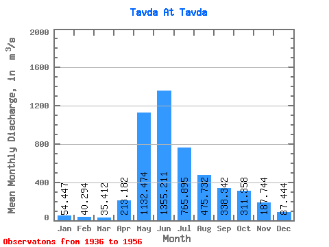
| Statistic | Jan | Feb | Mar | Apr | May | Jun | Jul | Aug | Sep | Oct | Nov | Dec | Annual |
|---|---|---|---|---|---|---|---|---|---|---|---|---|---|
| Mean | 54.45 | 40.29 | 35.41 | 213.18 | 1132.47 | 1355.21 | 765.89 | 475.73 | 338.34 | 311.36 | 187.74 | 87.44 | 439.21 |
| Standard Deviation | 20.44 | 16.20 | 16.13 | 195.12 | 533.58 | 709.73 | 464.69 | 501.45 | 321.95 | 187.19 | 100.29 | 40.15 | 211.08 |
| Min | 28.00 | 24.30 | 18.60 | 26.10 | 421.00 | 533.00 | 189.00 | 64.70 | 47.30 | 33.50 | 54.90 | 35.30 | 189.51 |
| Max | 96.30 | 78.70 | 72.00 | 688.00 | 2110.00 | 2730.00 | 1730.00 | 2290.00 | 1370.00 | 679.00 | 417.00 | 163.00 | 962.92 |
| Coefficient of Variation | 0.38 | 0.40 | 0.46 | 0.92 | 0.47 | 0.52 | 0.61 | 1.05 | 0.95 | 0.60 | 0.53 | 0.46 | 0.48 |
 Return to R-Arctic Net Home Page