|
|
|||||||||||||||||
| Point ID: 7234 | Downloads | Plots | Site Data | Code: 12413 |
|
|
|||||||||||||||||
| Download | |
|---|---|
| Site Descriptor Information | Site Time Series Data |
| Link to all available data | |
| View: | Time Series | All |
| Units: | m3/s |
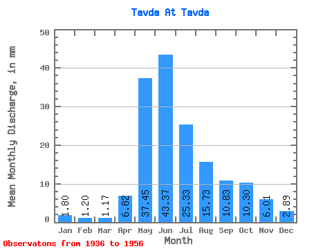
| Statistic | Jan | Feb | Mar | Apr | May | Jun | Jul | Aug | Sep | Oct | Nov | Dec | Annual |
|---|---|---|---|---|---|---|---|---|---|---|---|---|---|
| Mean | 1.80 | 1.21 | 1.17 | 6.82 | 37.44 | 43.37 | 25.32 | 15.73 | 10.83 | 10.29 | 6.01 | 2.89 | 171.13 |
| Standard Deviation | 0.68 | 0.49 | 0.53 | 6.24 | 17.64 | 22.71 | 15.36 | 16.58 | 10.30 | 6.19 | 3.21 | 1.33 | 82.24 |
| Min | 0.93 | 0.73 | 0.61 | 0.83 | 13.92 | 17.06 | 6.25 | 2.14 | 1.51 | 1.11 | 1.76 | 1.17 | 73.84 |
| Max | 3.18 | 2.37 | 2.38 | 22.02 | 69.76 | 87.36 | 57.20 | 75.71 | 43.84 | 22.45 | 13.34 | 5.39 | 375.18 |
| Coefficient of Variation | 0.38 | 0.40 | 0.46 | 0.92 | 0.47 | 0.52 | 0.61 | 1.05 | 0.95 | 0.60 | 0.53 | 0.46 | 0.48 |
 Return to R-Arctic Net Home Page