|
|
|||||||||||||||||
| Point ID: 7230 | Downloads | Plots | Site Data | Code: 12402 |
|
|
|||||||||||||||||
| Download | |
|---|---|
| Site Descriptor Information | Site Time Series Data |
| Link to all available data | |
| View: | Time Series | All |
| Units: | mm |
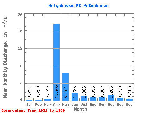
| Statistic | Jan | Feb | Mar | Apr | May | Jun | Jul | Aug | Sep | Oct | Nov | Dec | Annual |
|---|---|---|---|---|---|---|---|---|---|---|---|---|---|
| Mean | 0.29 | 0.24 | 0.44 | 17.66 | 6.40 | 1.73 | 1.07 | 0.85 | 0.89 | 1.27 | 0.77 | 0.49 | 2.68 |
| Standard Deviation | 0.19 | 0.18 | 0.50 | 9.46 | 6.51 | 1.18 | 1.04 | 1.13 | 1.16 | 1.78 | 0.74 | 0.49 | 1.32 |
| Min | 0.02 | 0.01 | 0.01 | 3.91 | 1.19 | 0.24 | 0.06 | 0.03 | 0.06 | 0.09 | 0.04 | 0.04 | 0.83 |
| Max | 0.71 | 0.76 | 2.73 | 43.40 | 35.10 | 5.09 | 4.08 | 5.41 | 4.81 | 8.71 | 3.49 | 2.78 | 6.81 |
| Coefficient of Variation | 0.64 | 0.77 | 1.14 | 0.54 | 1.02 | 0.69 | 0.98 | 1.33 | 1.31 | 1.41 | 0.96 | 1.01 | 0.49 |
 Return to R-Arctic Net Home Page