|
|
|||||||||||||||||
| Point ID: 7230 | Downloads | Plots | Site Data | Code: 12402 |
|
|
|||||||||||||||||
| Download | |
|---|---|
| Site Descriptor Information | Site Time Series Data |
| Link to all available data | |
| View: | Time Series | All |
| Units: | m3/s |
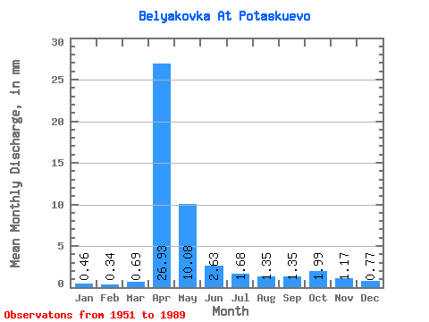
| Statistic | Jan | Feb | Mar | Apr | May | Jun | Jul | Aug | Sep | Oct | Nov | Dec | Annual |
|---|---|---|---|---|---|---|---|---|---|---|---|---|---|
| Mean | 0.46 | 0.34 | 0.69 | 26.93 | 10.08 | 2.63 | 1.68 | 1.35 | 1.35 | 2.00 | 1.17 | 0.77 | 49.72 |
| Standard Deviation | 0.29 | 0.27 | 0.79 | 14.43 | 10.26 | 1.80 | 1.64 | 1.79 | 1.77 | 2.81 | 1.12 | 0.77 | 24.48 |
| Min | 0.04 | 0.01 | 0.02 | 5.96 | 1.88 | 0.37 | 0.09 | 0.05 | 0.09 | 0.13 | 0.06 | 0.06 | 15.41 |
| Max | 1.12 | 1.09 | 4.30 | 66.17 | 55.29 | 7.76 | 6.43 | 8.52 | 7.33 | 13.72 | 5.32 | 4.38 | 126.41 |
| Coefficient of Variation | 0.64 | 0.77 | 1.14 | 0.54 | 1.02 | 0.69 | 0.98 | 1.33 | 1.31 | 1.41 | 0.96 | 1.01 | 0.49 |
 Return to R-Arctic Net Home Page