|
|
|||||||||||||||||
| Point ID: 7228 | Downloads | Plots | Site Data | Code: 12383 |
|
|
|||||||||||||||||
| Download | |
|---|---|
| Site Descriptor Information | Site Time Series Data |
| Link to all available data | |
| View: | Time Series | All |
| Units: | mm |
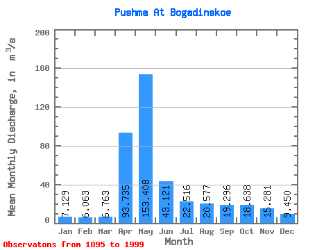
| Statistic | Jan | Feb | Mar | Apr | May | Jun | Jul | Aug | Sep | Oct | Nov | Dec | Annual |
|---|---|---|---|---|---|---|---|---|---|---|---|---|---|
| Mean | 7.13 | 6.06 | 6.76 | 93.73 | 153.41 | 43.12 | 22.52 | 20.58 | 19.30 | 18.64 | 15.28 | 9.45 | 35.52 |
| Standard Deviation | 4.12 | 3.91 | 4.63 | 80.09 | 115.29 | 37.48 | 22.18 | 25.57 | 21.51 | 21.93 | 13.61 | 6.22 | 20.57 |
| Min | 1.52 | 1.02 | 0.96 | 4.64 | 21.40 | 1.60 | 1.94 | 2.12 | 3.20 | 2.26 | 2.54 | 2.16 | 7.43 |
| Max | 22.00 | 19.70 | 23.70 | 338.00 | 661.00 | 201.00 | 122.00 | 172.00 | 101.00 | 138.00 | 86.10 | 36.70 | 103.57 |
| Coefficient of Variation | 0.58 | 0.64 | 0.69 | 0.85 | 0.75 | 0.87 | 0.98 | 1.24 | 1.11 | 1.18 | 0.89 | 0.66 | 0.58 |
 Return to R-Arctic Net Home Page