|
|
|||||||||||||||||
| Point ID: 7228 | Downloads | Plots | Site Data | Code: 12383 |
|
|
|||||||||||||||||
| Download | |
|---|---|
| Site Descriptor Information | Site Time Series Data |
| Link to all available data | |
| View: | Time Series | All |
| Units: | m3/s |
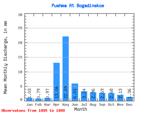
| Statistic | Jan | Feb | Mar | Apr | May | Jun | Jul | Aug | Sep | Oct | Nov | Dec | Annual |
|---|---|---|---|---|---|---|---|---|---|---|---|---|---|
| Mean | 1.03 | 0.80 | 0.97 | 13.06 | 22.09 | 6.01 | 3.24 | 2.96 | 2.69 | 2.68 | 2.13 | 1.36 | 60.27 |
| Standard Deviation | 0.59 | 0.51 | 0.67 | 11.16 | 16.60 | 5.22 | 3.19 | 3.68 | 3.00 | 3.16 | 1.90 | 0.90 | 34.90 |
| Min | 0.22 | 0.13 | 0.14 | 0.65 | 3.08 | 0.22 | 0.28 | 0.30 | 0.45 | 0.33 | 0.35 | 0.31 | 12.62 |
| Max | 3.17 | 2.58 | 3.41 | 47.10 | 95.17 | 28.01 | 17.57 | 24.76 | 14.07 | 19.87 | 12.00 | 5.28 | 175.73 |
| Coefficient of Variation | 0.58 | 0.64 | 0.69 | 0.85 | 0.75 | 0.87 | 0.98 | 1.24 | 1.11 | 1.18 | 0.89 | 0.66 | 0.58 |
 Return to R-Arctic Net Home Page