|
|
|||||||||||||||||
| Point ID: 7203 | Downloads | Plots | Site Data | Code: 12204 |
|
|
|||||||||||||||||
| Download | |
|---|---|
| Site Descriptor Information | Site Time Series Data |
| Link to all available data | |
| View: | Time Series | All |
| Units: | mm |
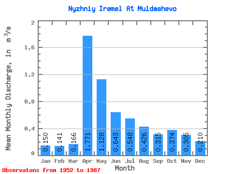
| Statistic | Jan | Feb | Mar | Apr | May | Jun | Jul | Aug | Sep | Oct | Nov | Dec | Annual |
|---|---|---|---|---|---|---|---|---|---|---|---|---|---|
| Mean | 0.15 | 0.14 | 0.17 | 1.77 | 1.13 | 0.64 | 0.55 | 0.43 | 0.32 | 0.37 | 0.30 | 0.21 | 0.55 |
| Standard Deviation | 0.13 | 0.09 | 0.11 | 1.06 | 0.64 | 0.43 | 0.58 | 0.40 | 0.21 | 0.28 | 0.21 | 0.15 | 0.18 |
| Min | 0.00 | 0.01 | 0.01 | 0.33 | 0.13 | 0.05 | 0.01 | 0.01 | 0.01 | 0.01 | 0.01 | 0.01 | 0.24 |
| Max | 0.58 | 0.45 | 0.43 | 4.77 | 3.11 | 2.09 | 3.01 | 1.48 | 0.84 | 1.43 | 0.96 | 0.64 | 1.07 |
| Coefficient of Variation | 0.87 | 0.65 | 0.65 | 0.60 | 0.57 | 0.67 | 1.06 | 0.94 | 0.68 | 0.76 | 0.70 | 0.74 | 0.33 |
 Return to R-Arctic Net Home Page