|
|
|||||||||||||||||
| Point ID: 7203 | Downloads | Plots | Site Data | Code: 12204 |
|
|
|||||||||||||||||
| Download | |
|---|---|
| Site Descriptor Information | Site Time Series Data |
| Link to all available data | |
| View: | Time Series | All |
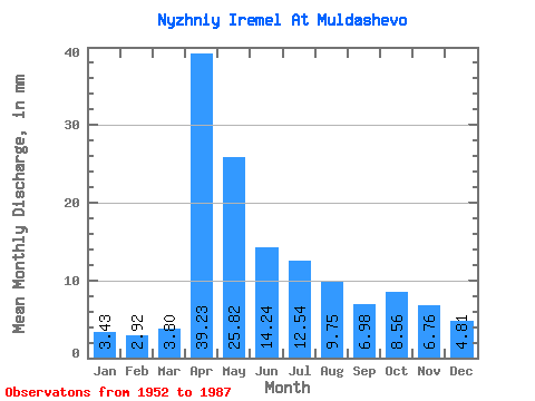
| Units: | m3/s |
| Statistic | Jan | Feb | Mar | Apr | May | Jun | Jul | Aug | Sep | Oct | Nov | Dec | Annual |
|---|---|---|---|---|---|---|---|---|---|---|---|---|---|
| Mean | 3.44 | 2.94 | 3.80 | 39.23 | 25.82 | 14.25 | 12.55 | 9.74 | 6.99 | 8.56 | 6.75 | 4.80 | 147.94 |
| Standard Deviation | 2.98 | 1.92 | 2.46 | 23.60 | 14.62 | 9.57 | 13.28 | 9.16 | 4.75 | 6.47 | 4.75 | 3.53 | 49.18 |
| Min | 0.05 | 0.17 | 0.21 | 7.31 | 2.98 | 1.02 | 0.25 | 0.18 | 0.13 | 0.21 | 0.13 | 0.16 | 63.62 |
| Max | 13.28 | 9.38 | 9.84 | 105.67 | 71.18 | 46.30 | 68.90 | 33.88 | 18.61 | 32.73 | 21.27 | 14.65 | 288.40 |
| Coefficient of Variation | 0.87 | 0.65 | 0.65 | 0.60 | 0.57 | 0.67 | 1.06 | 0.94 | 0.68 | 0.76 | 0.70 | 0.74 | 0.33 |
 Return to R-Arctic Net Home Page