|
|
|||||||||||||||||
| Point ID: 7200 | Downloads | Plots | Site Data | Code: 12197 |
|
|
|||||||||||||||||
| Download | |
|---|---|
| Site Descriptor Information | Site Time Series Data |
| Link to all available data | |
| View: | Time Series | All |
| Units: | mm |
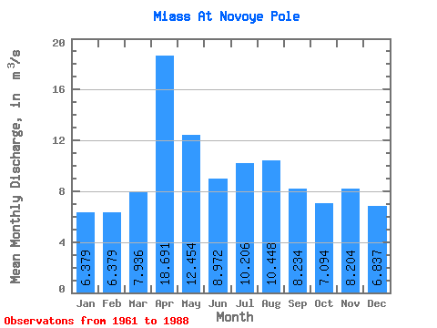
| Statistic | Jan | Feb | Mar | Apr | May | Jun | Jul | Aug | Sep | Oct | Nov | Dec | Annual |
|---|---|---|---|---|---|---|---|---|---|---|---|---|---|
| Mean | 6.38 | 6.38 | 7.94 | 18.69 | 12.45 | 8.97 | 10.21 | 10.45 | 8.23 | 7.09 | 8.20 | 6.84 | 9.40 |
| Standard Deviation | 1.09 | 1.10 | 2.99 | 17.58 | 12.64 | 5.20 | 7.96 | 8.80 | 4.46 | 1.79 | 5.89 | 2.05 | 4.31 |
| Min | 3.21 | 4.14 | 4.36 | 4.89 | 3.82 | 3.89 | 4.21 | 4.20 | 3.98 | 4.57 | 4.79 | 4.41 | 4.66 |
| Max | 8.12 | 8.49 | 16.90 | 77.00 | 59.60 | 23.40 | 35.00 | 36.70 | 24.60 | 11.90 | 36.70 | 13.40 | 21.29 |
| Coefficient of Variation | 0.17 | 0.17 | 0.38 | 0.94 | 1.01 | 0.58 | 0.78 | 0.84 | 0.54 | 0.25 | 0.72 | 0.30 | 0.46 |
 Return to R-Arctic Net Home Page