|
|
|||||||||||||||||
| Point ID: 7200 | Downloads | Plots | Site Data | Code: 12197 |
|
|
|||||||||||||||||
| Download | |
|---|---|
| Site Descriptor Information | Site Time Series Data |
| Link to all available data | |
| View: | Time Series | All |
| Units: | m3/s |
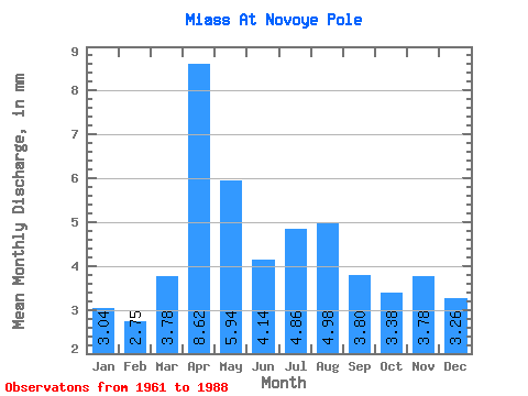
| Statistic | Jan | Feb | Mar | Apr | May | Jun | Jul | Aug | Sep | Oct | Nov | Dec | Annual |
|---|---|---|---|---|---|---|---|---|---|---|---|---|---|
| Mean | 3.01 | 2.74 | 3.74 | 8.53 | 5.87 | 4.09 | 4.81 | 4.93 | 3.76 | 3.34 | 3.74 | 3.22 | 52.22 |
| Standard Deviation | 0.51 | 0.47 | 1.41 | 8.02 | 5.96 | 2.37 | 3.75 | 4.15 | 2.03 | 0.84 | 2.69 | 0.97 | 23.95 |
| Min | 1.51 | 1.78 | 2.06 | 2.23 | 1.80 | 1.77 | 1.98 | 1.98 | 1.82 | 2.15 | 2.19 | 2.08 | 25.88 |
| Max | 3.83 | 3.65 | 7.97 | 35.14 | 28.10 | 10.68 | 16.50 | 17.30 | 11.23 | 5.61 | 16.75 | 6.32 | 118.29 |
| Coefficient of Variation | 0.17 | 0.17 | 0.38 | 0.94 | 1.01 | 0.58 | 0.78 | 0.84 | 0.54 | 0.25 | 0.72 | 0.30 | 0.46 |
 Return to R-Arctic Net Home Page