|
|
|||||||||||||||||
| Point ID: 72 | Downloads | Plots | Site Data | Code: 05AC027 |
|
|
|||||||||||||||||
| Download | |
|---|---|
| Site Descriptor Information | Site Time Series Data |
| Link to all available data | |
| View: | Time Series | All |
| Units: | mm |
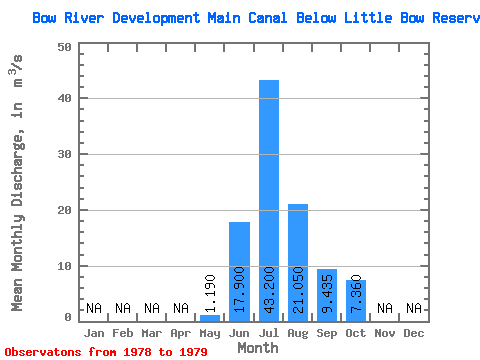
| Statistic | Jan | Feb | Mar | Apr | May | Jun | Jul | Aug | Sep | Oct | Nov | Dec | Annual |
|---|---|---|---|---|---|---|---|---|---|---|---|---|---|
| Mean | 1.19 | 17.90 | 43.20 | 21.05 | 9.44 | 7.36 | |||||||
| Standard Deviation | 9.76 | 3.11 | 1.06 | 3.34 | 0.10 | ||||||||
| Min | 1.19 | 11.00 | 41.00 | 20.30 | 7.07 | 7.29 | |||||||
| Max | 1.19 | 24.80 | 45.40 | 21.80 | 11.80 | 7.43 | |||||||
| Coefficient of Variation | 0.55 | 0.07 | 0.05 | 0.35 | 0.01 |
 Return to R-Arctic Net Home Page